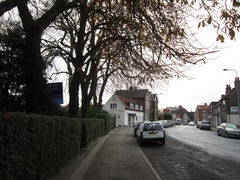
Church Street, twice
Ian S photographed Church Street twice. Both frames are on this page, with the credit under each one. They show a village-scale street: older buildings close to the footway, not the wide verges of a late-twentieth-century estate. A drive here is often a short standing beside a path, or a side access, rather than a double-width court in front of a detached house. If your plot is one of the newer closes off the old street, say so. The photographs will mislead a professional who thinks every Sutton address looks like Church Street.
This page uses the name Sutton-on-Hull so it is not confused with other Suttons. The map button lower down is aimed at Sutton-on-Hull, Hull. Press it only if you want Google to load. Until then the page does not embed a map.

Sutton Village on the conservation list
Hull's conservation-area list numbers Sutton Village among the city's areas. The Article 4 summary at the top of that download lists extra controls for places such as the Avenues and Pearson Park, including cross-overs and hard-standing areas, and for Garden Village it records boundaries and roof alterations. Sutton Village is not given that hard-surface line in the summary this site has read. Garden Village's later 2025 direction is a Garden Village instrument. It does not travel north to Church Street because both places are in east Hull.
Conservation-area status still matters. Demolition of an unlisted building in a conservation area, and works to trees, are not casual weekend jobs. GOV.UK's guidance on trees in conservation areas is the notice process: tell the authority before cutting, lopping or uprooting many trees, so a preservation order can be considered. A yew or a lime in a Church Street frontage should be named in the request. This page does not claim a grade for the church or for any house. Listing is a Historic England record. If your pack says the building is listed, consent for alterations is a separate question from a driveway quote.
Watercourses the strategy names
Hull's flood-strategy appendix on drainage is specific about the east of the city. It names Sutton Cross Drain and Old Fleet Drain as designated main rivers in the east, alongside the Holderness Drain, which it says discharges to the Humber. The River Hull runs through the middle of the city. These are catchment facts, not a statement that Church Street flooded on a given day. The flood map for planning is the address-level check. This website has not run that map for every house in the village, so it will not announce a flood zone.
What a drive can do is local and small. A sealed front that sheds water straight to a village footway adds a trickle to a system the strategy already describes as carrying water through Hull. A border, a permeable build-up, or a channel to a planted area is a design sentence worth having on the quote. It does not make the house safe from the Holderness Drain. It stops the garden being an afterthought.
The British Geological Survey viewer is the right place for the deposits under Sutton. The city's published geological account describes alluvium, glacial sands and gravels, and tidal deposits over chalk, with the mix changing by area. Sutton sits toward the eastern side, nearer the Holderness direction than the Wolds. Do not copy a base specification from Hessle or from The Avenues.
Crossings inside the city
Sutton-on-Hull is not an East Riding parish for these purposes. Hull City Council's dropped-kerb page is the highway process: approval, an approved contractor, and an offence if the crossing is built without that approval. The June 2025 pack's extra planning test for classified roads and for the Avenues/Hymers area is explained on the dropped kerbs page. Church Street's status is something to confirm against that pack, not something this page will guess.
A short village front often cannot take the turning diagram the pack gives for cases where planning permission is required. If the car cannot enter and leave in one movement, say that at the start. Some households only need a single standing they reverse into, and the council may or may not accept it. The quote should not pretend the manoeuvre is easy.
National rules on front gardens over five square metres are in the planning guide. They apply here in the same way as on other city streets that do not have a hard-standing Article 4. They are not a Sutton bylaw.
Newer edges of the village
Much of the housing people mean by Sutton is later than Church Street: closes and small estates that still use a Sutton address. Those streets are not automatically inside the Sutton Village conservation area. The boundary is the council's map. A 1990s close with a shared drive has a different brief again: the shared surface may belong to a management company or still be highway. Ask before anyone digs up a joint access and offends a neighbour or the highway authority.
Garden Village to the south-west has the 2025 hard-surface direction. Bransholme to the north-west is an estate the conservation list does not name. East Hull follows Holderness Road. Use the page that matches the street.
What to send
Write Sutton-on-Hull, the street, and whether the house is on Church Street or on a later close. Mention trees, a shared access, and any existing lowered kerb. Say how rain leaves the front today. The quote form is the route for that description. Hull Driveways does not read the form, does not quote the job, and does not install the drive.
Questions about Sutton-on-Hull
Is the hard-standing direction from Garden Village in force here?
No. That direction's schedule names the Garden Village conservation area and a list of excluded houses there. Sutton Village is a different conservation area, and the list this site used does not attach that hard-surface Article 4 to it.
Do I need the East Riding for a kerb?
Not if the house is inside Hull. Sutton-on-Hull in the city uses Hull City Council's crossing process. If a particular new estate has been built outside the boundary, the council map decides, not the estate name.
Can you tell me if the church is listed?
This page does not. Listing records are Historic England's. The photographs show Church Street. They are not a listing entry.
Sources: Conservation area list; Local flood risk strategy appendix, drainage; Hull dropped kerbs; GOV.UK trees in conservation areas; Flood map for planning; BGS Geology Viewer.